


Contact Info
8608 Highway 7 North
P.O. Box 189
Jessieville, AR 71949
- Phone:
- 501-984-5313
Basics
- Length:
- 0.9 mile round trip; 0.5 mile loop.
- Difficulty:
- Easy
- Time:
- 30 mins
Description
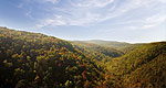
This fully accessible trail is ideal for a short day hike. It leads you through a picturesque mature pine and hardwood forest. You will enjoy a fishing pond, beautifully constructed bridges and interpretive signs along the trails edge. Facilities include a picnic pavilion and restroom. Located at the Jessieville Visitor Information and Ranger Station, volunteers and Forest Service personnel are ready to assist you with your information needs.
Surrounding areas:
Camp and picnic at Iron Springs Recreation Area.
For a longer hike try the Hunts Loop and Ouachita National Recreation Trail.
Enjoy a beautiful scenic drive on Scenic 7 Byway or Buffalo Gap Auto Tour if you are looking for a more primitive experience.
Historic Hot Springs National Park is only 19 miles away and Lake Ouachita offers a vast array of boating and water sport opportunities.
Details
Length:
Difficulty:
Time:
Additional Details:
Trail Information: The trail will take about 30
minutes to travel and is a paved surface. The
grade is very gentle.
Site Amenities: Restroom, parking area, pond,
picnic pavilion, picnic tables, water at the
Visitor Information Center
Difficulty level: Easiest
Requirements: The trail is open to pedestrian
traffic only
Recommended Season: Year round

