


Basics
- Length:
- 24.9 miles (40 km)
- Time:
- Take 1-2 hours to fully enjoy this byway.
Description
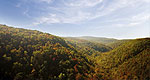
Travel to the highest point in Arkansas along the Mt. Magazine Scenic Byway. This winding mountain drive with its sharp curves and hairpin switchbacks will impart you with spectacular views of timber covered mountains, rugged rock bluffs and placid lakes.
Mt. Magazine shares a long history of mountain-top homesteads, and you can now enjoy a picnic on what was once a home site. The Forest Service operates the Cove Lake and Mt. Magazine recreation areas, so there are several opportunities for enjoyment in the shaded paths of the Ozark National Forest and the peaceful waters of Cove Lake. Put on your hiking boots or saddle up a horse to take advantage of the numerous hiking and horse trails in the forest. If you enjoy playing in the water more, Cove Lake is a favorite spot, with areas for swimming, fishing, boating and other water activities avaliable.
Park your car to fully take in the overlooks provided along the north and south slopes of Mt. Magazine, or spend a night at one of the many campgrounds provided. The Arkansas and Petit Jean River Valleys give a sweeping view of the patchwork of the many small farms that have been settled for generations. As you walk through the hushed pathways of the forest, make sure to note the varied wood, such as Short Leaf Pine, Red Oak, White Oak and Hickory. The ever changing fauna and flora along this byway provides the traveler with a variety of unique viewing possibilities.
Mt. Magazine Scenic Byway is easily accessible to Interstate 40 and a short drive to the Fort Smith National Historic Site. Take the whole family or just a group of friends and step back in time to see the remains of two frontier garrisons. Walk through the now silent halls of "Hangin' Judge Isaac C. Parker's courtroom, the jail and 1886 gallows.
Not only is Mt. Magazine the highest point in the state, it is considered the tallest mountain between the Rocky Mountains and the Appalachian Mountains. Whether you visit in the fiery colors of the autumn season, or the pastel colors of the spring, this byway provides numerous opportunities for scenic beauty and recreational fun.
Tourism Resources
Helpful Links
Tourism Resources
Points of Interest
Points of Interest Along The Way
Cove Lake Recreation Area (AR)
Located to the north of the mountain just off State Highway 309, the Cove Lake facility was built during the Works Progress Administration and the Civilian Conservation Corps era. Now operated by the forest service, the small, 160-acre mountain lake is a favorite area for watersports and provides opportunites for swimming, fishing, and boating.
Directions
Cove Lake Recreation ARea is in the Ozark National Forest just off State Highway 309.
Mt. Magazine State Park (AR)
At 2,753 feet, Mount Magazine is the highest point in Arkansas and from the top of the mountain, it is said you can see for hundreds of miles on a clear day. Visitors can enjoy sweeping vistas of the river valley or neighboring mountains like Petit Jean and Mount Nebo.
Temperatures on the plateau-like summit are usually 10-15degrees lower than the valley below, and these lower temperatures combined with altitude and geography make the perfect habitat for many rare species of plants and animals. Of special note is the butterfly population. Mt. Magazine boasts 94 of the 126 species of butterfly found in Arkansas, including the rare Diana Fritillary butterfly.
Mount Magazine State Park provides a number of differentrecreational opportunites, such as hiking, horseback riding,biking, rock rapelling and climbing, and hang gliding.
Directions
Between Havanna and Paris just off State Highway 309.
Ouachita National Forest - Arkansas (AR)
The Ouachita National Forest in central Arkansas covers 1.8 million acres. Headquartered in Hot Springs, Arkansas, the forest is managed for multiple uses.
Ozark National Forest (AR)
The Ozark National Forest covers 1.2 million acres, mostly in the Ozark Mountains of northern Arkansas. You'll find the tallest mountain in the State, Mount Magazine, and an incredible, living underground cave--Blanchard Springs Caverns.

