Rolling hills, meandering rivers and shady stands of forest provide a natural setting to complement the cultural heritage of the Ozark Mountains region in northwestern Arkansas.
Redding is a popular Mulberry River and Ozark Highlands Trail access point.
Details
Additional Details:
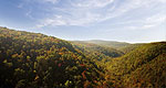
This 8.5-mile loop trail is located 18 miles north of Ozark, off Arkansas Highway 23. The trail takes the hiker to Spy Rock for a spectacular view of the Mulberry River Valley or to a junction with the Ozark Highlands Trail.
We offer a compact version of Go-Arkansas for mobile users, allowing you to access just the information you need on the road. Of course, you can still use the full version of Go-Arkansas on your mobile device just as you can on your desktop.